The City of New Westminster has released a report outlining their proposed vision for the 22nd Street Station area.
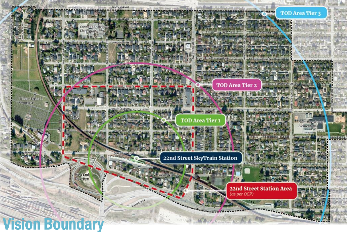
The 22nd Street Skytrain Station area is one of the lowest density Skytrain station areas in Metro Vancouver, and primarily a single family neighbourhood. The area was identified in the 2017 OCP for future planning consideration, which was originally commenced in February 2020 but put on pause until mid-2023. The Provincial TOA legislation has since informed the draft vision for the neighbourhood.
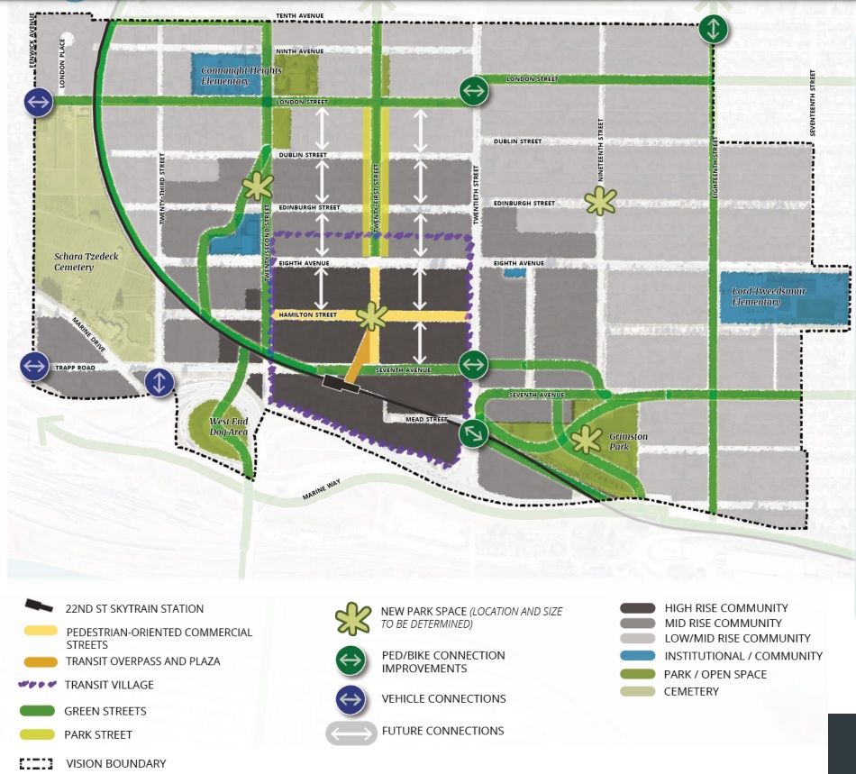
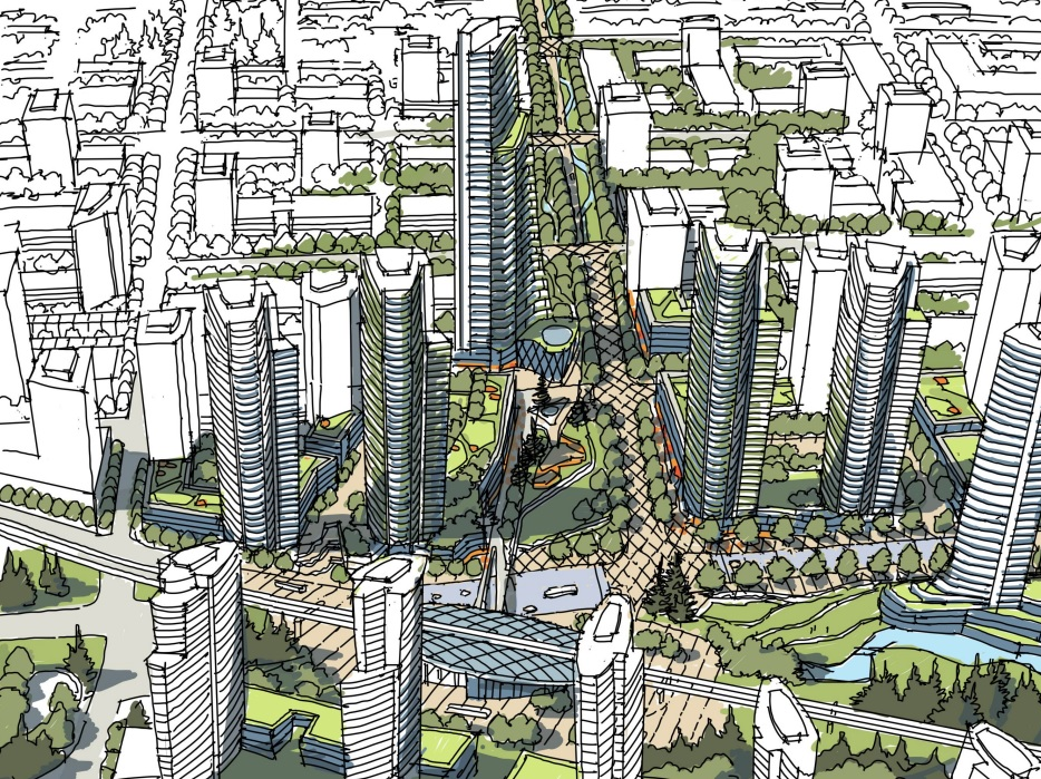
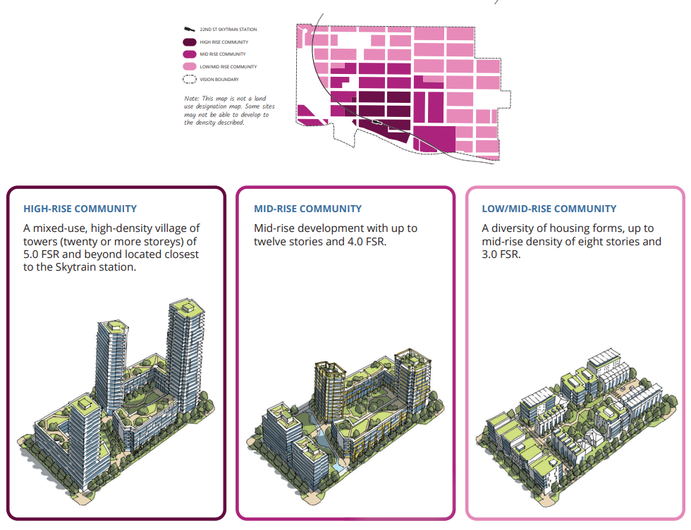
The overall concept for the area is a “Transit Village” that could house up to 30,000 new residents at full build out.
The indicated land use patterns align with the Provincial TOA legislation, allowing up to 5.0 FSR highrise development nearest the station, with 3.0 FSR lowrise development further out.
New Westminster intends on further public consultation this Fall, with a final draft to Council by December 2024, and OCP amendments to facilitate new rezoning applications in 2025.
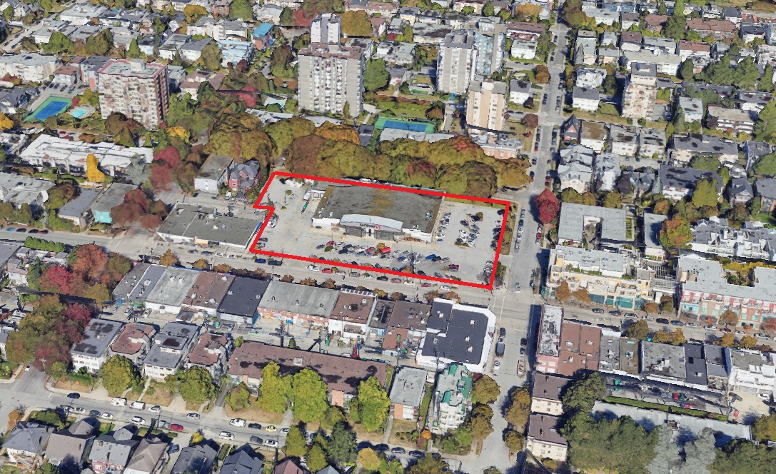
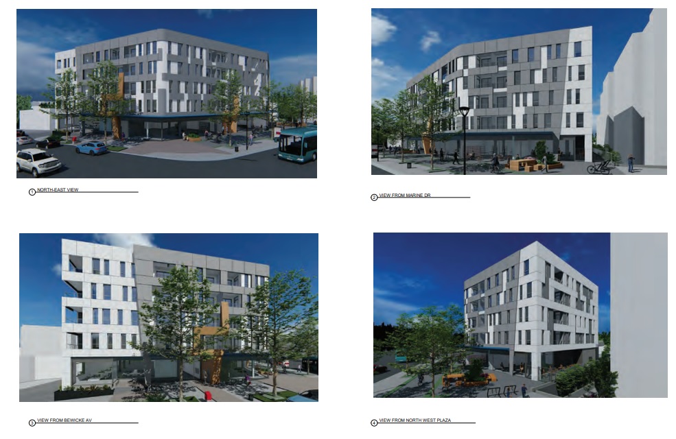
The Safeway property on West 4th Avenue and Vine Street in Kitsilano has been sold by Sobeys to a partnership between PCI Group and Low Tide Properties for $90,000,000.
The 2.2 acre property is zoned C-2B, which allows mixed use residential above ground floor commercial; up to 3.70 FSR and 6-storeys if the residential is rental. The Broadway Plan does not contemplate towers for the site.
No redevelopment plans have been announced but a likely development scenario under the existing zoning would include a 6-storey rental project with a new Safeway and additional retail on the ground floor.
The purchase price equates to $254 per buildable SF based on the existing zoning at a mixed-use rental density of 3.7 FSR.
City of Coquitlam council has released a report outlining the timing, process and scope of their OCP update.
As with other municipalities, work was already underway on an OCP review as of 2023 before the Provincial legislation changes. Now, the in-progress OCP review has been tweaked to accommodate the new legislation.
Coquitlam’s last full OCP was completed in 2002 and has been updated incrementally through various neighbourhood plans.
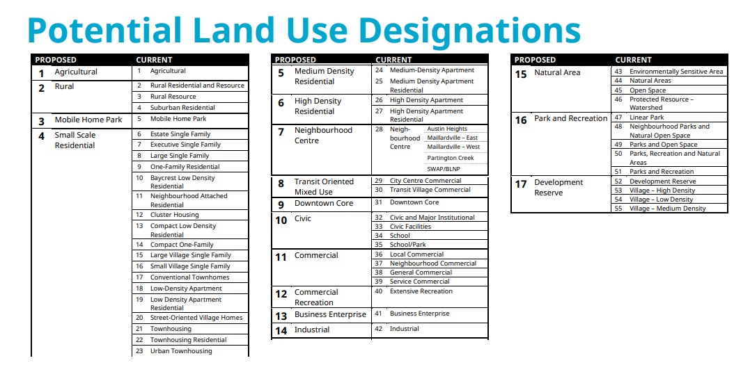
The staff presentation identifies potential land use designations:
Planning staff is now proposing an overhaul of the OCP, streamlining it by consolidating all neighbourhood plans into a single consolidated OCP, with all maps in dedicated schedules.
The report outlines the OCP update project as follows:
The OCP Review project is scheduled for completion in fall 2025, well ahead of the December 31, 2025 deadline for the provincial housing legislation OCP updates. The three high-level phases of the project are:
Prepare (completed): review and analyze existing content to inform and support the overall project;
Update (Summer 2024-Spring 2025): draft the necessary changes and prepare new draft document; and
Adopt (Summer-Fall 2025): bring a draft of the updated OCP forward for consideration and adoption.
City of Burnaby council will meet next week to review a report regarding the City’s OCP that outlines a Draft Land Use Framework for the entire City.
The City had been working on an update to the OCP entitled ‘Burnaby 2050’, since 2022. This is the first time that a draft land use document has been presented to the public showing potential land use for every lot.
The City is also working on a new Zoning Bylaw that will introduce a new “height-based development framework” in which land use designations are based on height (measured in storeys) as opposed to density and Floor Space Ratio (FSR). Details of the new Zoning Bylaw have not yet been released.
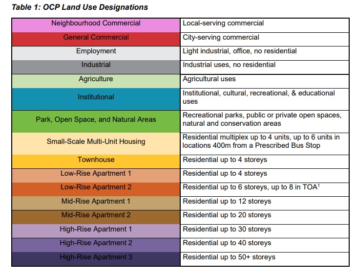
The new Official Community Plan Land Use Framework, and the corresponding Zoning Bylaw Districts are proposed to have seven (7) non-residential designations and nine (9) residential designations, each with a corresponding colour:
The updated draft land use plan accommodates the most recent TOA legislation (which was tabled by Burnaby council for 90 days) as well as upcoming Royal Oak and Edmonds Area Plans.
In addition to the land use designations, the City will be implementing a series of “Policy Overlays” to certain areas, blocks and lots. Examples of proposed Policy Overlays include: Rental Tenure, Streamside Development Permit Areas, Statutory Rights-of-Way, and Special Study Areas.
Community Benefit Density Bonus
The City has also outlined a new, modified density bonus program:
The OCP land use designations describe intended heights of buildings; however, a parcel may be eligible for additional height, beyond what is considered “additional supported height”, in exchange for provision of an on-site amenity or cash-in-lieu of an on-site amenity (“Community Benefit Density Bonus”), so long as it does not exceed the permitted height of the next most permissive land use category (if there is one).
Density bonusing opportunities are identified for the High-Rise Apartment 1, 2, and 3 designations, and may be considered in the Low-Rise 1, Low-Rise 2, Midrise 1, and Midrise 2 designations subject to City policy and bylaws.
Similar to the “additional supported height” scenarios, for residentially designated properties, additional height may be supportable so long as it does not exceed the permitted height of the next most permissive land use category (if there is one).
The draft land use map will be brought forward for public engagement in September 2024, with a report back to Council in late 2024 and an expectation of a final version in early 2025.