Vancouver Market - Chronicling Investment and Development Activity in Metro Vancouver
  • Home
  • Listings & Sales
  • Land Assembly
    • Official Community Plans (OCPs)
      • City of Burnaby
      • City of North Vancouver
      • District of North Vancouver
      • City of Vancouver
      • District of West Vancouver
    • Transit Oriented Areas (TOA) Policy
      • City of Burnaby
      • City of New Westminster
      • City of Vancouver
      • Transit Oriented Areas: How New Zoning Policy Affects Landowners
  • About
  • Subscribe
Vancouver Market - Chronicling Investment and Development Activity in Metro Vancouver
Home
Listings & Sales
Land Assembly
    Official Community Plans (OCPs)
    City of Burnaby
    City of North Vancouver
    District of North Vancouver
    City of Vancouver
    District of West Vancouver
    Transit Oriented Areas (TOA) Policy
    City of Burnaby
    City of New Westminster
    City of Vancouver
    Transit Oriented Areas: How New Zoning Policy Affects Landowners
About
Subscribe
  • Home
  • Listings & Sales
  • Land Assembly
    • Official Community Plans (OCPs)
      • City of Burnaby
      • City of North Vancouver
      • District of North Vancouver
      • City of Vancouver
      • District of West Vancouver
    • Transit Oriented Areas (TOA) Policy
      • City of Burnaby
      • City of New Westminster
      • City of Vancouver
      • Transit Oriented Areas: How New Zoning Policy Affects Landowners
  • About
  • Subscribe
Apartment, Development

Infill Rental Tower Proposed for West Van Apartment Property

A rezoning application has been submitted to add rental apartments to an existing rental apartment property at 1552 Esquimalt Avenue in West Vancouver. Ambleside Towers is a 21-storey, 185 unit concrete highrise built in 1970 on a nearly two acre site. The plan calls for the addition of new rental units on the underutilized Western portion of the site.

The application was initially made in 2016 but put on hold as part of West Vancouver’s revised OCP process. The proposal was brought forward again in late 2018 and now seek public input.

The proposal includes the following:

  • a new 17-storey rental apartment tower;
  • 131 rental units (including 20 ground oriented units)
    • 16 studios, 60 one-bedrooms, 54 two-bedrooms & 1 three-bedroom unit;
  • a total combined site density of 2.99 FAR;
  • a total building height of 170 ft.;
  • 83 new parking spaces (for a total on site of 208)

The architect for the project is Buttjes Architecture.

May 10, 2019by david.taylor@colliers.com
Apartment, Development, Office, Retail

Master Plan for Landsdowne Mall Site to Include 24 Towers

The owner of Lansdowne Centre, Vanprop Investments, has submitted their formal OCP amendment application to the City of Richmond for the purpose of approving a Master Land Use Plan for the 50 acre site, located in the heart of Richmond’s City Centre at the centre of the Lansdowne Village. It is immediately adjacent to the Lansdowne Canada Line Station, and is bound by No.3 Road, Alderbridge Way, Kwantlen Street and Lansdowne Road. Initial plans to redevelop the mall were announced two years ago.

While the density for the site is already established in the City Centre Area Plan (“CCAP”), the Master Plan is required to organize the eventual phasing, massing and heights of the future mixed-use development, as well as the location of the 10 acre park planned for the site. City of Richmond council endorsement means that the proposal can now move toward a community consultation phase. 

The shopping centre on the site was built in 1977 and exemplifies the auto-oriented enclosed shopping centre design popular in the 60’s and 70’s. The arrival of the Canada Line in 2010 with a station right next door and the subsequent CCAP made this site a prime target for future redevelopment, particularly since the surface parking can accommodate immediate development without requiring demolition of the existing mall.

The site has a mix of zoning designations, including Urban Core T6 (up to 4.0 FAR) on the westerly 1/3 of the site, and Urban Centre T5 (up to 2.0 FAR) on the easterly 2/3 of the site. The CCAP also identified the site for a 10 acre linear park running east/west along the southern portion of the site fronting Lansdowne Road.

Here is a summary of some of the concepts identified in the proposed master plan which has already achieved support for moving through the next steps in the process:

  • An overall density of 2.77 FAR (approx. 6,000,000 SF)
  • 22 residential towers and 2 office towers
  • 73% of the density within 400 metres of Lansdowne Station
  • A 53,500 SF community amenity building at corner of No.3 Road & Lansdowne
  • A new 10 acre park in the centre of the site (revised shape from CCAP)
  • Retail/entertainment space with residential and office space above fronting Hazelbridge Way (high street)
  • A new civic plaza near the Canada Line Station
  • Building heights up to 47 metres
  • New north/south extension of Hazelbridge Way and Cooney Road between Alderbridge Way and Lansdowne Road
  • New east/west road to connect No. 3 Road and Kwantlen Street
  • Target of 2035 for entire build out

Next Steps

The proposed OCP amendment process will require further consultation and refinement to the details in the master plan before final council approval and subsequent rezoning applications for individual phases. Consultation would take place in the spring 2018 with approval likely later next year. Below is the City’s flowchart outlining the process:

Proposed Master Land Use Plan

The architect for the master plan is Dialog.

December 15, 2017by david.taylor@colliers.com
Development

District of North Vancouver Set to Adopt Final Maplewood Village Centre Plan

The District of North Vancouver is set to adopt the final version of the Maplewood Village Centre and Innovation District Implementation Plan & Design Guidelines at council. 

Maplewood had been identified for future density in the DNV’s OCP back when it was adopted in 2011, but planning efforts for Maplewood didn’t formally get underway in 2015.

Overall the Maplewood Plan maintains a low and mid-rise built form, character, and scale. Highest density development within the Maplewood area is to be located within the compact village core. Possible locations for taller buildings ( up to 12 storeys) are included in the land use plan along with policy statements to include provisions to negotiate density and height on a case-by-case basis in order to achieve the District’s housing and community amenity objectives.

The Plan also includes an area being called the “Innovation District”, which comprises several acres of land controlled by Darwin Properties including former Port Metro Vancouver Lands, and a recently acquired boarding school property.

Here are some targets contained with the Maplewood plan:

  • 1,500 net new housing units by 2030
  • 4,500 net new jobs by 2030
  • 100,000 SF of commercial space
  • 300 net new non-market housing units
  • two new parks
  • various transportation improvements including extension of Berkeley Road and B-Line extension from Phibbs Exchange to Maplewood
  • Various community amenities including new community centre.

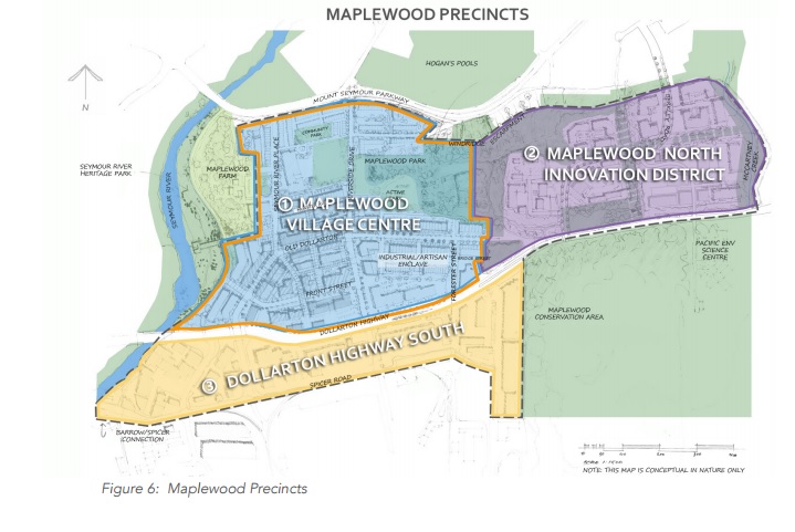
The Plan features three precincts:

1. Maplewood Village Centre is the central commercial hub and includes a diversity
of multi-family housing, mixed-use commercial/residential, live/work and smallscale
artisan industrial housing, as well as institutional uses including a school and
local community services.

2. Maplewood North Innovation District is a new district offering an innovative mix
of employment, educational, recreational and limited residential and community uses in a campus-style structure. This area will be connected to the Village Centre
by major arterial routes and an active transportation network. Parks, open space
and natural areas are integrated throughout to create a connected network.

3. Dollarton Highway South is a strong industrial and employment area with
opportunities to intensify as existing and local business expand and provides
opportunities for the expansion of business park uses.

Land uses within the plan includes the following:

  • Residential densities at 1.20 – 2.50 FSR
  • Mixed-Use densities at 1.75 – 2.50 FSR
  • Commercial densities up to 1.0 FSR
  • Industrial densities up to 1.10 FSR
  • Mixed Industrial densities up to 2.50 FSR

A full version of the Maplewood Plan can be viewed here: http://app.dnv.org/OpenDocument/Default.aspx?docNum=3376593

November 5, 2017by david.taylor@colliers.com
Page 3 of 12« First...«2345»10...Last »

Search the Site

Tweets by vancouvermrkt

Categories

  • Apartment
  • Condo
  • Development
  • For Sale
  • Hotel
  • Investment
  • Land
  • Market Research
  • Office
  • Rental
  • Retail


David Taylor Personal Real Estate Corporation

Colliers International

© 2019 Copyright  |  All Rights Reserved