Vancouver Market - Chronicling Investment and Development Activity in Metro Vancouver
  • Home
  • Listings & Sales
  • Land Assembly
    • Official Community Plans (OCPs)
      • City of Burnaby
      • City of North Vancouver
      • District of North Vancouver
      • City of Vancouver
      • District of West Vancouver
    • Transit Oriented Areas (TOA) Policy
      • City of Burnaby
      • City of New Westminster
      • City of Vancouver
      • Transit Oriented Areas: How New Zoning Policy Affects Landowners
  • About
  • Subscribe
Vancouver Market - Chronicling Investment and Development Activity in Metro Vancouver
Home
Listings & Sales
Land Assembly
    Official Community Plans (OCPs)
    City of Burnaby
    City of North Vancouver
    District of North Vancouver
    City of Vancouver
    District of West Vancouver
    Transit Oriented Areas (TOA) Policy
    City of Burnaby
    City of New Westminster
    City of Vancouver
    Transit Oriented Areas: How New Zoning Policy Affects Landowners
About
Subscribe
  • Home
  • Listings & Sales
  • Land Assembly
    • Official Community Plans (OCPs)
      • City of Burnaby
      • City of North Vancouver
      • District of North Vancouver
      • City of Vancouver
      • District of West Vancouver
    • Transit Oriented Areas (TOA) Policy
      • City of Burnaby
      • City of New Westminster
      • City of Vancouver
      • Transit Oriented Areas: How New Zoning Policy Affects Landowners
  • About
  • Subscribe
Development, Market Research

Broadway Planning Program Comes Into Focus

The City of Vancouver will next week present a policy report  to the Standing Committee on Policy and Strategic Priorities that outlines the forthcoming Broadway Planning Program. 

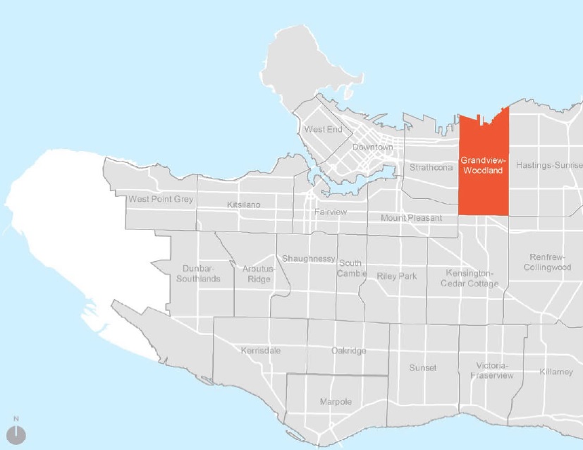
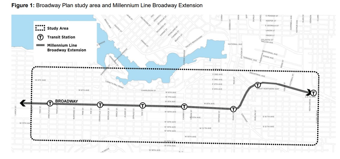
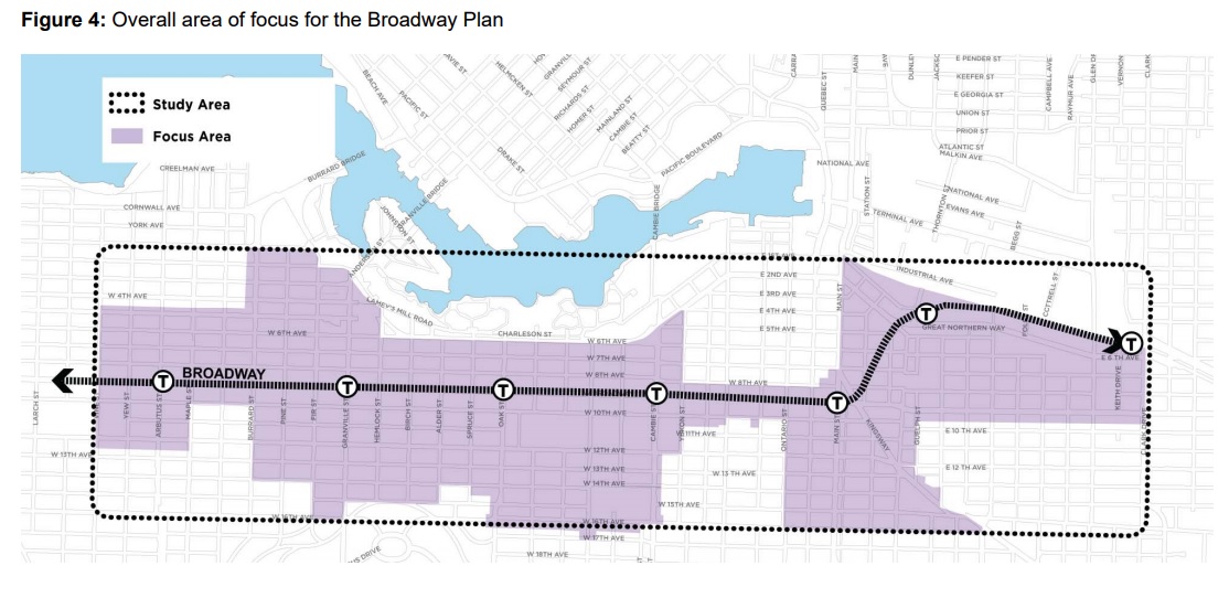
The planning initiative seeks to develop a comprehensive land use policy plan for the Broadway area in conjunction with the anticipated Broadway subway extension to Arbutus Street. The overall Broadway Plan study area, shown in an outline below, includes lands from Clark Drive in the east to Vine Street (two blocks west of Arbutus Street) in the west. The north and south boundaries (16th Avenue) boundaries of the overall study area were determined by considering areas up to 800 metres from existing and future stations. 

From the report: “The plan will focus on opportunities to integrate development with the future transit along and around the Millennium Line Broadway Extension (Broadway Extension) to support the City’s goals of creating housing affordability, job space, social and cultural amenities, environmental sustainability and livability. Council is asked to adopt an interim rezoning policy that will apply while the planning program is underway and to approve an associated planning program budget.”

Timeline

The plan is expected to be finalized by December 2020, with the following anticipated 5 phases:

Initial – Background Phase (expected completion December 2018) comprehensive range of studies, including an area demographic profile, archaeological assessment, baseline utility capacity review, rate of change impact assessment, statement of significance/heritage assessment, transportation modelling, parking data collection and review, Broadway Extension project planning as well as other studies to inform the planning program work.

Five phases:

  1. Guiding Principles (expected completion June 2019) 
    • planning principles (coordinated with and informed by broader City Core 2050 guiding principles).
  2. Emerging Directions (expected completion December 2019) 
    • growth scenarios and patterns for change in land uses, housing, jobs, parks and public spaces, transportation connections and amenities (coordinated with and informed by broader City Core 2050/Economy Lands Studies, and Broadway Extension project design)
  3. Refining Directions (expected completion – June 2020) 
    • draft policy plan for land use, density, layout, built form, and design. This will
      integrate policies to increase social and rental housing, while retaining existing rental and increasing protection for tenants.
    • draft public amenity strategy addressing housing, community amenities,
      transportation connections, infrastructure, parks, public space, public realm
      improvements, and social and cultural amenities. 
  4. Finalizing the Plan (expected completion – December 2020)
    • final policy plan, including enhanced renter protection policy in the Rental
      Housing Stock ODP areas included in the study area.
    • final public amenity strategy.
  5. Implementation (to be determined)
    • rescinding Interim Rezoning Policy
    • referral of by-law amendments and subsequent policy amendments (e.g. to
      Community Plans)

Area of Study

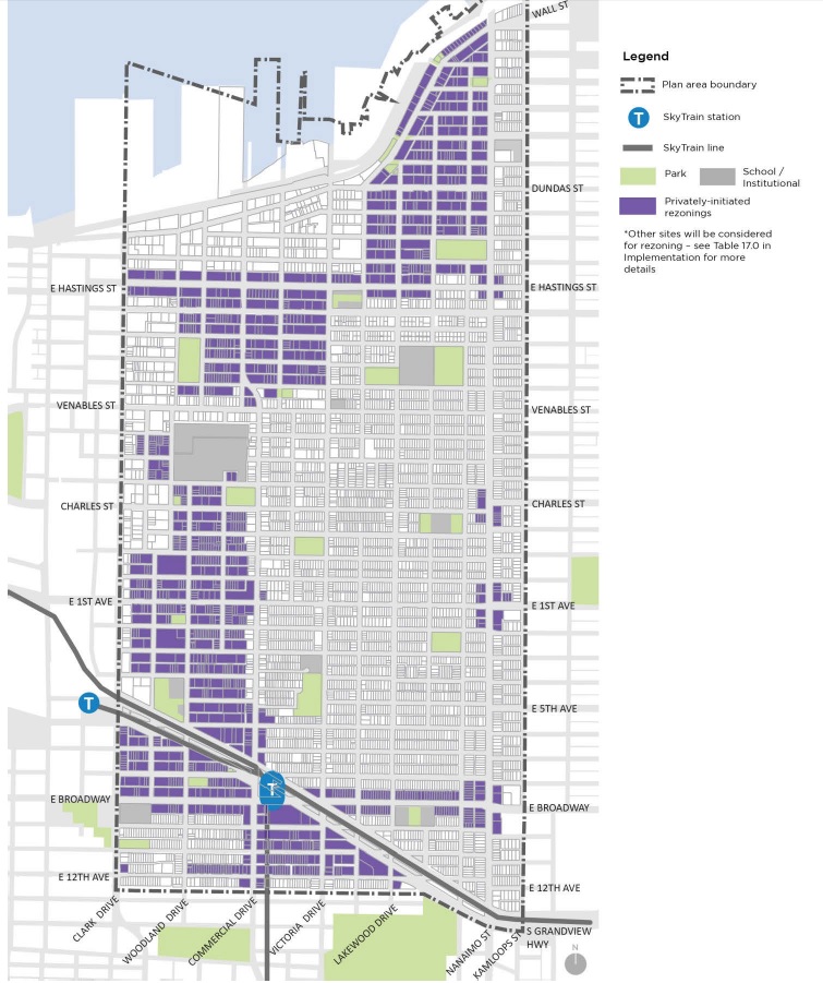
Within the overall study area there is a focus area to be reviewed for potential land use
change as shown on the map below, shaded in purple. Generally, this includes the C-3A, C-2, RM-3/4, FM zoned areas, and parts of the Burrard Slopes mixed employment area within proximity to the station areas, as well as VGH and City Hall Campus. It excludes RS and RT zones, the False Creek South and the Southeast False Creek ODP areas, the majority of the Mount Pleasant industrial zones and False Creek Flats industrial and mixed employment zones. The RS and RT zones will be addressed through the ‘Making Room: Adding Housing Choice in Neighbourhoods Across Vancouver’ Planning Program, a key action item coming from the Housing Vancouver Strategy that is also going before council next week (click link above for details).

Policy Considerations

The City also notes a number of other policy consideration that will shape future development scenarios. These include:

  • The Rental Housing Stock Official Development Plan – City will explore renewal and retention of existing rental apartment stock. The rental districts within the study area make up one of the City’s core rental areas, containing 17,680 units of existing non-market and market rental housing – including 27% of the City’s total purpose-built rental units in areas covered by the Rental Housing Stock ODP. Planning work will explore potential future options for these sites, noting that rental replacement and enhanced tenant protection and relocation will be prioritized. 
  • Jobs and Economy Policies – the Metro Core Jobs Plan is being updated by the Employment Lands and Economy Review Study set for 2019. In conjunction with that study, the Broadway Planning will consider protection of lands for job space and provision of new commercial density. Existing industrial zones will be largely excluded, save for a small stretch on 8th Avenue.
  • Heights, Views & Other Considerations – 
    • Queen Elizabeth View Corridor (View #3) – testing will occur to explore whether select buildings along Broadway could enter into view 3.1 without
      eroding the overall view of the city within nature
    • Vancouver General Hospital Flight Path – VGH has a helicopter pad for emergency transport to and from the hospital. The VGH flight path is a wide apron that swings out to the north of the VGH heliport. Transport Canada limits building heights along Broadway – quite considerably between Oak
      and Laurel Streets.The City and VGH have agreed that proposals
      for new towers will be brought forward for review and discussion with VGH, Transport Canada and the helicopter operators. 
    • C-3A Guidelines (Views to City Hall) The Cambie Street (east side) C-3A Guidelines and Central Broadway C-3A Urban Design Guidelines which restrict heights along Broadway between Laurel Street and Yukon Street in order to preserve views to City Hall from public points along the north
      side of the False Creek seawall will be reviewed. 
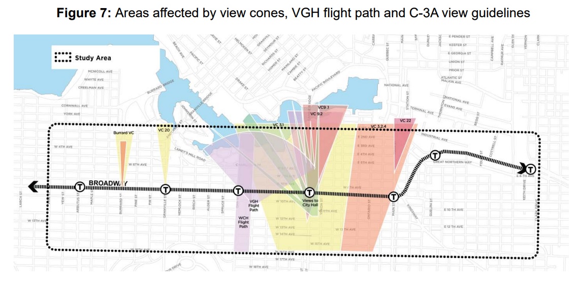
    • Community Plans – The Broadway Plan study area includes lands covered by three Community Plans: Mount Pleasant Community Plan (2010), Kitsilano Neighbourhood Plan (1977), and Fairview (1974) – these will be reviewed as part of the process.
    • Vancouver General Hospital (VGH) and City Hall Campus – As both City Hall and VGH will be undertaking master planning initiatives to plan for their future in the near term, the larger context of these two major employment
      campuses and the area’s role as an important gateway to the City Core will be considered through Broadway planning.

Other Interim Measures

Interim Rezoning Policy During Broadway Planning Process

The City will seek to limit rezoning applications being made until the plan is finalized. It appears that new rezoning applications will only be considered for public or non-profit institutional, cultural, or recreational uses, non-market housing, or heritage retention.

New Policy Measure to Curb Speculation

As has been highlighted in recent media attention, the City will also put measures in place to prevent any land speculation over the planning phase under a new policy entitled: Development Contribution Expectations in Areas Undergoing Community Planning. This will include a new Development Contribution Expectation (“DCE”) that will charge a pre-determined rate based on existing zoning and independent consultants’ review of the economic viability of proposed projects factoring in the prioritization of job space and affordable housing.

From the report: “The overarching objective of the DCE policy is to curb land value speculation in the market. This objective is best achieved by providing buyers and sellers with clear and consistent information about the City’s priorities and objectives for the Broadway Planning program. With the information, buyers and sellers will be able to properly account for the City’s expectations when identifying a fair price for land on the Corridor.”

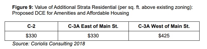
The report further notes that achieving additional density above existing zoning for strata will be limited.

The Broadway Planning Program policy report goes to Standing Committee on Policy and Strategic Priorities next week. A full version of the report can be viewed here: http://council.vancouver.ca/20180620/pspc20180620ag.htm


June 14, 2018by david.taylor@colliers.com
Market Research

Updated Grandview Woodlands Plan Unveiled

After initially launching the planning process for the Grandview Woodlands neighbourhood of East Vancouver in March 2012, the City of Vancouver has released what is expected to be the final draft of the plan that will go to Council for approval in the next few weeks.

The initial draft concept plan caused widespread opposition and resulted in the City pulling back by forming a Citizens’ Assembly and subsequently a two year process of community engagement.

GW2

The resulting draft plan, which was released this weekend, contains few surprises, but generally lays out how the area is likely to be developed in the coming years in an area forecast to grow to 43,500 people by 2041.

Here is a sub-area breakdown for those unfamiliar:

“The Drive”

GW31. Retain the existing mixed‐use zoning (4-storeys or less) throughout the core blocks of Commercial Drive.
2. Maintain the pattern of smaller, individual retail frontages to help keep The Drive eclectic and active.
3. Outside of core and only on larger sites at the East 1st Avenue node, allow buildings up to 6-storeys/3.0 FSR to provide new housing.

Grandview

GW7

1. Modify regulations to discourage demolition of pre‐1940 houses.
2. Expand the duplex areas and revise regulations to encourage new infill housing.
3. Preserve the small‐scale local serving shops.
4. On arterial streets and in transition areas near transit routes on Hastings and on Broadway, allow a mix of four‐ storey apartments and rowhouses for families.
5. In the apartment district at the north end, allow buildings up to 6‐storeys / 2.4 FSR to provide renewed and additional secured rental housing while protecting character streetscapes.

HastingsGW4

1. Create a new gateway area near Clark Drive that incorporates renewed cultural, social and heritage assets, along with non‐market and other housing, with the tallest buildings at 18‐storeys. Range of densities highest at 4.0 to 5.6 FSR.
2. Improve pedestrian comfort along Hastings Street with public plazas that will activate and unify the street.
3. Support renewal and expansion of key social facilities such as those provided by the Urban Native Youth Association and the Vancouver Aboriginal Friendship Centre.
4. Step buildings down to heights in the 8‐ to 10‐storey range (3.0 – 4.0 FSR) as one goes eastward up the hill towards Victoria Drive and provide new rental and ownership housing.
5. Retain the existing mixed‐use zoning (4-storeys or less) in the Hastings Village shopping area near Nanaimo Street.
6. Allow for 100% secured market rental housing in buildings up to 6-storeys in the central portions of Hastings Street.

Cedar CoveGW5

1. Maintain the existing protected rental housing stock while allowing for managed rental replacement and new supply in buildings up to 6-storeys (2.4 FSR) in the area west of Nanaimo Street and up to 4-storeys on the eastside of Nanaimo Street.
2. Expand the neighbourhood shopping node at Dundas and Wall to allow for more services closer to home.
3. Preserve the significant character streetscapes that have been identified.
4. To the north of the shopping node, encourage expansion of Oxford Park by allowing for mixed‐use buildings in the 8 to 12-storey range (3.2 FSR).
5. Protect the city’s industrial and port‐related jobs while improving the interface with residential areas.

Britannia WoodlandGW6
1. Maintain the existing protected rental housing stock while allowing for managed rental replacement and new supply in buildings up to 6-storeys / 2.4 FSR.
2. Preserve significant character streetscapes that have been identified and allow infill housing to encourage retention of older buildings.
3. On selected blocks on Pender Street, adjacent to the new gateway neighbourhood along Hastings Street, allow buildings up to 10-storeys / 3.2 FSR  to achieve new non‐market and other housing.
4. Retain space for local jobs and improve the interface between industrial and residential uses.

Nanaimo

GW8

1. Allow ground‐oriented housing, such as rowhouses suitable for families, along much of Nanaimo Street.
2. At commercial shopping nodes, allow mixed‐use buildings of between 4 and 6-storeys (2.0 – 3.0 FSR) to help bring new life to the local shopping nodes.
3. Improve pedestrian comfort in the public realm to activate and unify the street.

Commercial‐Broadway Station Precinct

GW91. Create a new social heart for the community with a new civic plaza as part of a renewed Safeway site with ground‐floor commercial uses and new housing in buildings ranging from 12‐ to 24‐storeys (up to 5.7 FSR).
2. Near the station, allow mixed‐use and mixed‐tenure buildings ranging from 6 to 10-storeys.
3. In the Station Precinct residential areas, maintain the existing protected rental housing stock while allowing for managed rental replacement and new supply in 4 to 6‐storey buildings and 10‐storey buildings (4.0 FSR) on larger sites, provided that all new units are secured as rental housing.
4. Allow 6‐storey buildings on East Broadway and rowhouses in selected areas to provide family housing close to transit.
5. In the low‐scale, traditional character area located west and south of the transit station, allow duplex and two‐family dwellings with a focus on infill housing to retain character buildings.
6. Create new office space close to the rapid transit station.


How quickly the Grandview Woodlands plan area develops will be partially dependent upon market conditions but will also be shaped by the way in which the City of Vancouver will allow development to proceed per the Plan.

As was the case with both the Marpole Community Plan and the West End Community Plan, the Grandview Woodlands Community Plan divides the plan area into different sub-areas; effectively rezoning many areas and leaving others to be rezoned by proponents in the future. This ensures that larger scale projects will go through a typical rezoning process and smaller duplex and rowhouse projects will simply require development permits.

The proposed two areas are broken down as follows:

City-Initiated Rezoning Areas

These areas will be effectively “rezoned” and therefore will not require a lengthy application process and public hearing for each development.

GW12Privately Initiated Rezoning Areas

The map below depicts areas that will require a developer or building owner to apply for a rezoning and go through a typical rezoning process.

GW10Community Amenity Contributions (CACs)

Below is a map outlining where there will be a fixed-rate CAC target and where CACs will be negotiated on an application basis.

GW11A full copy of the draft Grandview Woodlands Community Plan can be downloaded at the City’s website: http://vancouver.ca/home-property-development/grandview-woodland-community-plan.aspx

June 27, 2016by david.taylor@colliers.com
Development

Mayor Says Grandview-Woodland Plan Could be ‘Delayed Significantly’

When it comes to controversial neighbourhood plans, especially in Grandview-Woodlands, Vancouver Mayor Gregor Robertson says the city has shifted gears to listen to the public.

“Certainly with Grandview-Woodland and Marpole, I’ve said clearly we’re not going forward with the current timeline,” Robertson said to reporters at a Wednesday launch event for the city’s online public engagement tool, Talk Vancouver.

City council is expected to decide on Sept. 25 whether to extend the community plan, along with three other community plans underway in Marpole, the West End and the Downtown Eastside.

“I think we’ll see Grandview-Woodland delayed significantly and a lot more work, back to the drawing board, to make sure that voices are heard and that we shape the plan for the long-term of that neighbourhood as best as possible,” Robertson said.

Read more: http://metronews.ca/news/vancouver/792663/vancouver-mayor-says-grandview-woodland-plan-could-be-delayed-significantly/

September 12, 2013by david.taylor@colliers.com
Page 1 of 212»

Search the Site

Tweets by vancouvermrkt

Categories

  • Apartment
  • Condo
  • Development
  • For Sale
  • Hotel
  • Investment
  • Land
  • Market Research
  • Office
  • Rental
  • Retail


David Taylor Personal Real Estate Corporation

Colliers International

© 2019 Copyright  |  All Rights Reserved