Vancouver Market - Chronicling Investment and Development Activity in Metro Vancouver
  • Home
  • Listings & Sales
  • About
  • Subscribe
Vancouver Market - Chronicling Investment and Development Activity in Metro Vancouver
Home
Listings & Sales
About
Subscribe
  • Home
  • Listings & Sales
  • About
  • Subscribe
Development, Market Research, Office

Details Emerge for Coquitlam’s Updated City Centre Area Plan

The City of Coquitlam Council will receive a report next week for information and feedback regarding residential density and land use transition approach for the City Centre Area Plan (CCAP) Update. The planning update got underway last year, and it is anticipated that a draft plan will be presented to Council in Summer 2019.

The original CCAP was developed in 2008, and updated with a Transit Oriented Development Strategy in 2012. This update was initiated to capitalize on the Evergreen Line, with an intent to prioritize high density development around the new station areas. The City Centre update projects 24,000 new residents by 2046.

The focus for proposed new residential density will be broadly defined in two separate areas:

Core Area 

The majority of land use changes to the existing 2008 CCAP are proposed around
the Coquitlam Centre and Lincoln Skytrain stations. Currently, the maximum permitted density for all residential and commercial uses under the City Centre Commercial land use designation (C-4 zone) is 6.5 FAR inclusive of density available for affordable housing, with a 0.5 FAR commercial floor space requirement. It is proposed that a maximum FAR of 6.5, inclusive of density available for affordable housing, and a 1.0 commercial FAR requirement be applied in the Commercial Downtown Core until a comprehensive review of the City’s density bonus program is completed. 

The City separately reviewed commercial densities in a discussion paper released last month in which an increase in minimum commercial densities in the City Centre was recommended.

For areas designated as City Centre Commercial outside of the Commercial Downtown Core, the existing 6.5 FAR maximum, inclusive of density available for affordable housing, and 0.5 FAR commercial floor would be maintained.

Shoulder Area

Outside of the Commercial Downtown Core and City Centre Commercial designation, a combination of high and medium density residential rounds out the residential density and land use transition.

High density residential allows up to a 5.5 FAR, inclusive of density available for
affordable housing, under the RM-6 zone without any height limit and the medium density land use allows up to a 2.64 FAR, inclusive of density available for affordable housing, under the RM-3 zone with a height limit up to 8-storeys.

To provide a transition to the adjacent lower density neighbourhoods, site
specific height limits are proposed for high density (20-25 storey) and medium
density (4-6 storey) residential areas. Although proposed residential land use changes are primarily within the CCAP Focus Area, staff recommends a land use change for the area east of Inlet Street and south of Tahsis Avenue from low density apartment residential and townhousing to medium density with a 4-6 storey height limit.

A medium density land use form with a 4-6 storey height limit in this area will serve as a transitional land use between the Commercial Downtown Core and peripheral areas in City Centre and blend into adjacent established, lower density neighbourhoods.


A draft plan will be developed with a final round of public consultation and council consideration later this year.

Further detail on the City Center Area Plan update can be viewed on the City of Coquitlam’s website, here: https://www.coquitlam.ca/planning-and-development/resources/special-plans-projects/city-centre-area-plan-update

March 8, 2019by david.taylor@colliers.com
Development, Market Research

Top 10 Land Deals of 2018

2018 has been another record year for land sales in Metro Vancouver approaching $5 Billion in total sales value, surpassing both 2016 & 2017, with $4.5 and $4.4 Billion respectively. This record year is really the culmination of several large deals which were marketed and negotiated prior to the market cooling down earlier this year.

Here’s a look at each of the 10 largest land deals of 2018:

1. 9850 Austin Road, Burnaby

  • Price:                   Approx. $220 Million*
  • Site Area:            4.1 acres
  • Vendor:               Greystone
  • Purchaser:          Pinnacle International

The goods:        The largest land deal of 2018 is one you might not even have heard of. The sale comprised a large site adjacent the Lougheed Skytrain Station on the Burnaby side of Burquitlam that the City of Burnaby designated as High Density Mixed Use within the Lougheed Town Centre Master Plan. Density may range from 2.2 FAR to 5.0 FAR for RM5s zoning districts and 6.0 FAR for C-3 zoning districts. The site was listed and sold by Cushman & Wakefield. (* – the exact purchase price could not be verified due to share sale. The deal also included an unspecified VTB).


2. Burnaby Saputo Site, 6800 Lougheed Highway, Burnaby

  • Price:                  $209 Million
  • Site Area:           19 acres
  • Vendor:               Saputo
  • Purchaser:          Peterson Group

The goods:          The second largest land deal of 2018 was the sale of Saputo’s 19-acre Burnaby plant to Peterson Group was completed in October for $209,000,000. The site had been listed by Cushman & Wakefield in early 2017 and the transaction involves the relocation of Saputo’s dairy plant operations to a new processing plant on a 20 acre site on Kingsway Avenue in Port Coquitlam, which is expected to be completed within the next three years. In the interim, their sale deal with Peterson envisions a lease back until their new plant is ready in 2021. Rezoning and development plans have not been released but a large-scale mixed use development is anticipated.


3. 1045 Haro Street & 830-850 Thurlow Street, Vancouver

  • Price:                  $165 Million
  • Site Area:           43,266 SF
  • Vendor:               Strata
  • Purchaser:          Private Investor

The goods:          This sale involved the wind-up and sale of a 160 unit strata building, along with commercial units at the corner of Haro Street and Thurlow Street in the West End. The site sits in a newly formed tower zone as part of the West End Community Plan.  A rezoning application will be required before development can occur.


4. 8671-8831 Cambie Road and 3480-3540 Sexsmith Road, Richmond

  • Price:                  $147 Million
  • Site Area:           12.4 acres
  • Vendor:               RCG Group
  • Purchaser:          Polygon

The goods:          This land assembly by Polygon creates a great development site on the Eastern edge of Richmond’s City Centre Area. The assembly was the precursor to a rezoning application which envisions over 1,200 residential units and retails space in six buildings.


5. 1640-1650 Alberni Street, Vancouver

  • Price:                  $130 Million
  • Site Area:            17,292 SF
  • Vendor:               Hollyburn Properties
  • Purchaser:          Landa Global

The goods:         This tower site was owned by well-established family-owned Hollyburn Properties who had planned to rezone the site for a 42-storey rental building. With valuations for condos at an all-time high, Hollyburn wisely decided to sell the site through Simon Lim and James Lang of Colliers. While a new rezoning application has yet to be filed, the site will almost certainly now become a mix of condos and rentals.


6. 1063-1075 Barclay Street, Vancouver

  • Price:                  $113 Million
  • Site Area:           17,292 SF
  • Vendor:              Westbank & Bosa Properties
  • Purchaser:         Grand World Holdings

The goods:         Another tower site in the coveted West End Community Plan, this assembly of separate strata buildings reached a stalemate between developers who decided to sell together, rather than to each other. Simon Lim of Colliers sold the site in May 2018 to a Hong Kong based investor/developer. The Globe and Mail detailed the sale in March 2018.


7. “Park West”, Capilano and Marine, North Vancouver

  • Price:                 $98 Million
  • Site Area:          1.9 acres
  • Vendor:              Pacific Gate Investments
  • Purchaser:         Keltic Canada Development

The goods:         This 1.9 acre site at the corner of Capilano Road and Marine Drive in North Vancouver was rezoned by a group of local private investors over a period of years to allow a 258-unit, two-tower development that was ultimately named “Park West”. After rezoning enactment, the site was sold to emerging developer Keltic Canada. Park West is now in the advanced stages of marketing with over half the units sold.


8. 101 East 69th Avenue & 86 SE Marine Drive, Vancouver

  • Price:                  $90 Million
  • Site Area:           12.5 acres
  • Vendor:              Walmart Canada
  • Purchaser:         Hungerford Properties

The goods:        This site was sold by the Colliers team of David Taylor, Roy Pat and Darren Cannon in February 2018. The vacant site was owned for several years by Walmart Canada who ultimately sold via off-market transaction to Hungerford Properties who has quickly become one of Vancouver’s pre-eminent industrial and commercial property developers.


9. 5720-5800 Minoru Boulevard, Richmond

  • Price:                  $60 Million
  • Site Area:           3.899 acres
  • Vendor:              Private Investors
  • Purchaser:         Thind Properties

The goods:        This sale represents an assembly of various industrial and commercial buildings in the Lansdowne Village subearea of the City of Richmond’s City Centre area. A subsequent rezoning application envisions a new development with 384 residential units and a total density of 3.0 FAR.


10. 6645 Dow Avenue, Burnaby

  • Price:                 $59 Million
  • Site Area:           40,946 SF
  • Vendor:              Private Local Investors
  • Purchaser:         Westorchard Properties

The goods:       Also sold by Simon Lim of Colliers, this is Metrotown’s last RM5s/C2 Development site on Beresford Street – 40,946-SF Metrotown development site. The property is currently improved with a 40-unit apartment building, providing stable holding income through the rezoning and entitlement process.

*Note: The adjacent 34,650 SF site at 6675-6691 Dow Avenue also closed recently to the same buyer through Mark Goodman. The sale price was $43,275,000. The $102 Million combined price tag would create one of the largest deals of the year.


Honorable Mentions

These ones just fell off the list (via later edit) or are technically longer term land plays:

1140 Pendrell Street, Vancouver

  • Price:                 $57 Million
  • Site Area:          30,261 SF
  • Vendor:              Strata
  • Purchaser:         Skyllen Pacific

The goods:        This West End development site was sold by Hart Buck and Jennifer Darling of Colliers in September 2018 after a listing process. The Property, improved with an older lowrise strata building, is zoned RM-5B which allows for immediate redevelopment for up to 2.75 FSR density. Under the current zoning, the land price equates to $687 per buildable SF.


443 Seymour Street & 605-621 Seymour Street, Vancouver

  • Price:                 $100 Million
  • Site Area:          18,720 SF
  • Vendor:              Private Investor
  • Purchaser:         Reliance Properties

The goods:       This parkade (known by many locals as the Goldie’s pizza building) was sold via off-market transaction to well known commercial owner/developer Reliance Properties in July 2018. The site is anticipated for redevelopment with a new office building approximately 30 storeys in height.


Some notes from the above list:

  • Only 4 of the 10 largest land deals in Metro Vancouver took place in the City of Vancouver (down from 9 of 10 last year)
  • 7 of 10 were sold by market bid process (the other 2 were ‘off-market’)
  • 5 of 10 were bought by well-established ‘local’ development groups, the other buyers were offshore or ‘new-entrant’ development companies
  • 7 of 10 will require a rezoning process before development can occur
December 7, 2018by david.taylor@colliers.com
Development, Market Research

City of Vancouver Imposing New City-Wide Utilities DCL

Next week, City of Vancouver Council will consider a report from the Engineering and Planning Departments seeking to approve a new City-wide utilities development cost levy (DCL) and a long term capital projects program for upgrades. The report also confirms the Utilities Servicing Plan for the Cambie Corridor Phase 3 area and the CAC target rates for the Cambie Corridor and Marpole areas.

Here is a summary of these new recommendations.

New Utilities DCL

The need for infrastructure upgrades was highlighted during the latter stages of the Cambie Phase 3 planning in which significant new density was introduced in the Oakridge Transit Centre area in plans laid out in 2017. A reassessment of the future demand on sewer, drainage and water service capacity has led to this city-wide strategy. The City is now looking at increasing DCL rates to help finance the servicing requirements across multiple developments rather than piggybacking off of the initial developments in certain areas.

The recommended new DCL framework for financing water, sewer and drainage utilities
upgrades includes a long-term capital program of approximately $1 Billion and the introduction of a dedicated City-wide Utilities DCL to cover approximately $547 Million of that cost (benefit to new development) through DCL’s by 2026.

Currently, utilities are embedded in the overall City-wide DCL rates, but the utilities component will now be separated in order to “improve transparency and certainty for developers.” 

The report highlights the utilities portion of current DCL and the proposed Utilities DCL to demonstrate the increased rates:

Interestingly, a background study by Coriolis Consulting noted the following (from report):

  • New residential development downtown and on the west side of the city could
    accommodate the proposed rate increases.
  • New residential development on the east side of the city has less ability to absorb
    the new DCL costs without impacting economic feasibility.
  • For new non-residential development, Coriolis found in last year’s DCL report to the City that an increased DCL rate would have a negative impact on sites that are currently viable for redevelopment. For new industrial development, it would be challenging for most projects to support any increase in DCL rates given the
    inherent challenging economics. Similarly, it would also be challenging for most new office development to support an increased DCL rate.
  • In all cases where there is a DCL rate increase, it is preferable to phase-in the rate increase so new development can adjust to the increased costs.

The report also recommends that the Utilities DCL be waived for market rental housing (Most rental rezonings are eligible for DCL waiver) on an interim basis until 2020 with a review by staff coming next year.

The new DCL rates will come into effect on September 30, 2018 (rates are protected for in-stream applications for one year from the effective date).


Utilities Servicing Plan for Cambie Corridor & CAC Rates

The City approved the Cambie Corridor Phase 3 Plan at council in May, though the land use plan has remained subject to a pending Utilities Servicing Plan, which intends to lay out the development sequence of sites based upon utilities upgrades.

Highlights of the plan include:

  • City-initiated rezoning (“prezoning”) of townhouse areas in Stage 1 in the
    short-term (anticipated for referral and public hearing in summer/fall of 2018)
  • Requirement for basic onsite rainwater and groundwater management

Here is a guideline for development in the Cambie Phase 3 area:


Lastly, here are the proposed new CAC target rates for the Cambie Corridor and Marpole Areas:

Cambie Corridor

Marpole


The full report can be viewed here: https://council.vancouver.ca/20180711/documents/cfsc1.pdf

July 6, 2018by david.taylor@colliers.com
Development, Market Research

Broadway Planning Program Comes Into Focus

The City of Vancouver will next week present a policy report  to the Standing Committee on Policy and Strategic Priorities that outlines the forthcoming Broadway Planning Program. 

The planning initiative seeks to develop a comprehensive land use policy plan for the Broadway area in conjunction with the anticipated Broadway subway extension to Arbutus Street. The overall Broadway Plan study area, shown in an outline below, includes lands from Clark Drive in the east to Vine Street (two blocks west of Arbutus Street) in the west. The north and south boundaries (16th Avenue) boundaries of the overall study area were determined by considering areas up to 800 metres from existing and future stations. 

From the report: “The plan will focus on opportunities to integrate development with the future transit along and around the Millennium Line Broadway Extension (Broadway Extension) to support the City’s goals of creating housing affordability, job space, social and cultural amenities, environmental sustainability and livability. Council is asked to adopt an interim rezoning policy that will apply while the planning program is underway and to approve an associated planning program budget.”

Timeline

The plan is expected to be finalized by December 2020, with the following anticipated 5 phases:

Initial – Background Phase (expected completion December 2018) comprehensive range of studies, including an area demographic profile, archaeological assessment, baseline utility capacity review, rate of change impact assessment, statement of significance/heritage assessment, transportation modelling, parking data collection and review, Broadway Extension project planning as well as other studies to inform the planning program work.

Five phases:

  1. Guiding Principles (expected completion June 2019) 
    • planning principles (coordinated with and informed by broader City Core 2050 guiding principles).
  2. Emerging Directions (expected completion December 2019) 
    • growth scenarios and patterns for change in land uses, housing, jobs, parks and public spaces, transportation connections and amenities (coordinated with and informed by broader City Core 2050/Economy Lands Studies, and Broadway Extension project design)
  3. Refining Directions (expected completion – June 2020) 
    • draft policy plan for land use, density, layout, built form, and design. This will
      integrate policies to increase social and rental housing, while retaining existing rental and increasing protection for tenants.
    • draft public amenity strategy addressing housing, community amenities,
      transportation connections, infrastructure, parks, public space, public realm
      improvements, and social and cultural amenities. 
  4. Finalizing the Plan (expected completion – December 2020)
    • final policy plan, including enhanced renter protection policy in the Rental
      Housing Stock ODP areas included in the study area.
    • final public amenity strategy.
  5. Implementation (to be determined)
    • rescinding Interim Rezoning Policy
    • referral of by-law amendments and subsequent policy amendments (e.g. to
      Community Plans)

Area of Study

Within the overall study area there is a focus area to be reviewed for potential land use
change as shown on the map below, shaded in purple. Generally, this includes the C-3A, C-2, RM-3/4, FM zoned areas, and parts of the Burrard Slopes mixed employment area within proximity to the station areas, as well as VGH and City Hall Campus. It excludes RS and RT zones, the False Creek South and the Southeast False Creek ODP areas, the majority of the Mount Pleasant industrial zones and False Creek Flats industrial and mixed employment zones. The RS and RT zones will be addressed through the ‘Making Room: Adding Housing Choice in Neighbourhoods Across Vancouver’ Planning Program, a key action item coming from the Housing Vancouver Strategy that is also going before council next week (click link above for details).

Policy Considerations

The City also notes a number of other policy consideration that will shape future development scenarios. These include:

  • The Rental Housing Stock Official Development Plan – City will explore renewal and retention of existing rental apartment stock. The rental districts within the study area make up one of the City’s core rental areas, containing 17,680 units of existing non-market and market rental housing – including 27% of the City’s total purpose-built rental units in areas covered by the Rental Housing Stock ODP. Planning work will explore potential future options for these sites, noting that rental replacement and enhanced tenant protection and relocation will be prioritized. 
  • Jobs and Economy Policies – the Metro Core Jobs Plan is being updated by the Employment Lands and Economy Review Study set for 2019. In conjunction with that study, the Broadway Planning will consider protection of lands for job space and provision of new commercial density. Existing industrial zones will be largely excluded, save for a small stretch on 8th Avenue.
  • Heights, Views & Other Considerations – 
    • Queen Elizabeth View Corridor (View #3) – testing will occur to explore whether select buildings along Broadway could enter into view 3.1 without
      eroding the overall view of the city within nature
    • Vancouver General Hospital Flight Path – VGH has a helicopter pad for emergency transport to and from the hospital. The VGH flight path is a wide apron that swings out to the north of the VGH heliport. Transport Canada limits building heights along Broadway – quite considerably between Oak
      and Laurel Streets.The City and VGH have agreed that proposals
      for new towers will be brought forward for review and discussion with VGH, Transport Canada and the helicopter operators. 
    • C-3A Guidelines (Views to City Hall) The Cambie Street (east side) C-3A Guidelines and Central Broadway C-3A Urban Design Guidelines which restrict heights along Broadway between Laurel Street and Yukon Street in order to preserve views to City Hall from public points along the north
      side of the False Creek seawall will be reviewed. 
    • Community Plans – The Broadway Plan study area includes lands covered by three Community Plans: Mount Pleasant Community Plan (2010), Kitsilano Neighbourhood Plan (1977), and Fairview (1974) – these will be reviewed as part of the process.
    • Vancouver General Hospital (VGH) and City Hall Campus – As both City Hall and VGH will be undertaking master planning initiatives to plan for their future in the near term, the larger context of these two major employment
      campuses and the area’s role as an important gateway to the City Core will be considered through Broadway planning.

Other Interim Measures

Interim Rezoning Policy During Broadway Planning Process

The City will seek to limit rezoning applications being made until the plan is finalized. It appears that new rezoning applications will only be considered for public or non-profit institutional, cultural, or recreational uses, non-market housing, or heritage retention.

New Policy Measure to Curb Speculation

As has been highlighted in recent media attention, the City will also put measures in place to prevent any land speculation over the planning phase under a new policy entitled: Development Contribution Expectations in Areas Undergoing Community Planning. This will include a new Development Contribution Expectation (“DCE”) that will charge a pre-determined rate based on existing zoning and independent consultants’ review of the economic viability of proposed projects factoring in the prioritization of job space and affordable housing.

From the report: “The overarching objective of the DCE policy is to curb land value speculation in the market. This objective is best achieved by providing buyers and sellers with clear and consistent information about the City’s priorities and objectives for the Broadway Planning program. With the information, buyers and sellers will be able to properly account for the City’s expectations when identifying a fair price for land on the Corridor.”

The report further notes that achieving additional density above existing zoning for strata will be limited.

The Broadway Planning Program policy report goes to Standing Committee on Policy and Strategic Priorities next week. A full version of the report can be viewed here: http://council.vancouver.ca/20180620/pspc20180620ag.htm


June 14, 2018by david.taylor@colliers.com
Development, Market Research

A Synopsis of the Housing Vancouver Strategy

By now you’ve probably seen in the media that the City of Vancouver has released an outline of the much anticipated Housing Vancouver Strategy, first announced in 2016 under then new General Manager of Planning Gil Kelley. 

For those unfamiliar, the Housing Vancouver Strategy was announced as a broad City-wide planning initiative intended to address some aspects of the current housing affordability crisis. The specific policies being proposed come as a result of over a year of public and expert consultation as well as internal planning review. As the City’s report outlines, the main intent of these policies is: “to address the rampant commodification of housing and speculative demand, shift our housing toward the ‘Right Supply’, and ensure affordability, protection, and support for our most vulnerable residents.”

Perhaps not surprisingly, the Strategy will yield significant policy changes in the year leading up to the Civic Election. Notwithstanding any political motivations, from a planning perspective, the Strategy is one of the most ambitious planning programs outside of any specific neighbourhood plan, and could result in significant changes to single family areas and the low density areas around East Van transit stations and some apartment areas.

Overall the ten-year plan is intended to create:

  • 72,000 new housing units, including;
    • 12,000 social, supportive and co-op units
    • 20,000 new purpose-built rental units
    • 30,000 new condo units (incl. 1,000 laneway homes and 5,000 townhouses)

The full staff report can be downloaded here: http://council.vancouver.ca/20171128/documents/rr1.pdf

Below is a summary of the ten key policy recommendations being proposed:

  1. A) Shift toward the Right Supply

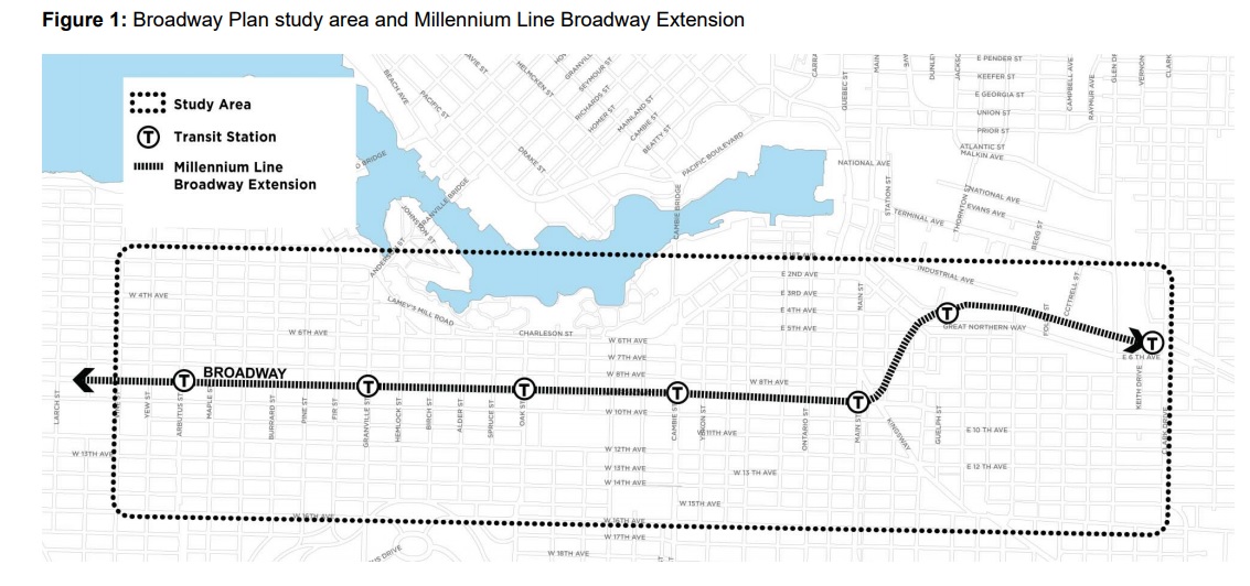
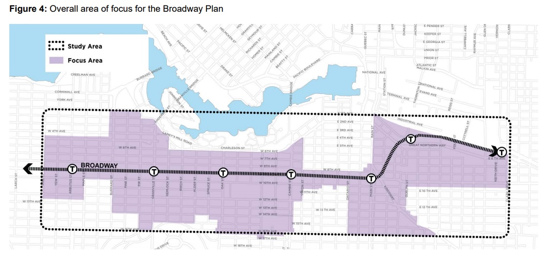
The City plan to launch major planning programs near transit hubs that don’t yet have density including: Nanaimo Station, 29th Station and Olympic Village Station. The City is also already starting a Broadway Corridor Planning Program.

This is potentially the biggest takeaway for developers, investors and those in the RE industry. The Skytrain Station announcement had been anticipated for well over two years but had yet to be formalized in a policy announcement.

B) Implement the Moderate Income Rental Housing Pilot Program

This is essentially an extension of the Rental 100 program, except further incentives would be offered to developers that include 20% of the gross floor area to “moderate income households” targeting between $30,000 and $80,000 per year. 

The Pilot program will consist of 20 rezoning applications between January 2018 and July 2019. 

Incentives include: 

  • Additional density
  • DCL Waivers
  • Access to grants and senior gov’t financial support programs
  • Parking requirement deductions
  • Relaxation of unit size minimums (ie. micro suites)

C) Advance the Transformation of Low Density Neighbourhoods to Increase Housing Variety

This particular policy direction has the potential to be one of the most dramatic. It could entail densification of single family areas, both near transit and in other areas. The City specifically mentions “Low density areas in the western and southern areas” as candidates for new housing. Potential options being explored include: allowing multiple dwellings in low-density neighbourhoods, including secondary suites, multiple suites, laneway housing, duplexes, triplexes, and fourplexes with secondary suites; as well as the creation of new townhouse zones).

While perhaps not as transformational in terms of density as the Nanaimo/29th/Olympic Village areas, the prospect of townhouses in areas such as Kerrisdale and Dunbar could prove the most contentious and will be interesting to watch.

TIMING: Beginning in 2018.


2. Limiting Speculative Investment – Develop a New Policy to Stabilize Land Values in Planning Programs 

The City will seek to take quick action to limit speculation developing a new interim public benefits strategy designed to curb speculative value. The City would, for example, set the CAC target rate prior to the launch of new planning programs in an effort to curb speculative purchases. This will be tested initially as part of the Broadway Corridor Planning work.

TIMING: Beginning early 2018.


3. Develop a New 10 Year Affordable Housing Delivery and Financial Strategy 

The City is going to look at how to deliver more social and supportive housing through review of various delivery and business models. These include:

  • Investigating feasibility of establishing a housing endowment to
    build and sustain affordable housing on a portfolio basis
  • Clarifying the role and mandate of VAHA as the delivery agent for affordable housing on City land
  • Leveraging senior levels of government, non-profit and private sector partners
  • Specifying the partner investment and/or contribution required to meet housing
    Vancouver targets for the lowest income households

TIMING: Report to Council by Spring 2018.


4. Partner in the Development a 10 Year Regional Urban Indigenous Housing Strategy

The City intends on developing a strategy to work three local first nations groups to address housing issues over a 10 year strategy plan. The strategy will include the delivery of 500-600 housing units at five properties: 950 Main, 1015 E
Hastings, 1618 E Hastings, 1607 E. Hastings, and 235-285 E 5th Avenue.

TIMING: Already underway.


5. Launch a New Social Purpose Real Estate Incentive Program 

The City will also launch a new “Social Purpose Real Estate Incentive Program” to encourage development of new and redevelopment of existing non-profit housing on non-profit owned sites. The program will explore:

  • Enhancing the City’s Housing Infrastructure Grant program to support affordable housing where partners, usually non-profits and co-ops, are seeking to build affordable housing on their own land
  • Additional density, ownership of assets, aligning the per door grant with affordability, combined with low-cost and predictable federal and provincial financing
  • Supporting the development of affordable housing on land owned by faith-based and nonprofit service organizations

TIMING: a draft strategy/policy by Fall 2018.


6. Accelerate SRO Replacement while Improving the Existing Stock to
Enhance Affordability, Livability and Supports to Tenants

The City intends on protecting the SRO stock and SRO tenants through a “two-pronged approach”: 

  • A goal of replacing 50% of the remaining private SROs with new self-contained social housing in 10 years.
  • Improve the affordability, livability and supports for SRO tenants through: new SRO Revitalization Fund, an enforcement and regulatory approach to existing SROs and portection against further loss and displacement

TIMING: Already underway.


7: Temporary Modular Housing 

The City has requested BC Housing funding for 1,200 units over the next two years, with 600 units expected to be delivered in 2018.

TIMING: Already underway.


8. Increase Rental Protections

The City has always placed emphasis on protecting existing rental stock and this has become increasingly important as rents have skyrocketed and redevelopment pressure is at an all time high. 

The City will explore opportunities to redevelop existing rental housing in order
to increase the overall supply of rental housing, while prioritizing affordability and ensuring protections for existing tenants. The City will undertake a review of the Rental Housing Stock ODP and Rate of Change areas, to:

  • Continue to ensure no net loss of rental units
  • Reduce the threshold that triggers one-for-one replacement (e.g. from 6 to 3 units)
  • Identify opportunities to redevelop and expand existing rental housing while preserving affordability

The City will also seek to enhance capacity to assist tenants with relocation needs through the creation of a new Tenant Protection Manager.

TIMING: Report to Council by Spring 2018.


9: Remove Barriers to Support Diverse Ways of Living – Enable Collective
Housing

The City says that they “heard during the Housing Vancouver engagement process that more residents are living in non-traditional housing arrangements and forms to improve affordability and help them stay in the city (e.g. collective housing, co-housing, tiny homes, live aboard boat options, etc.)”

The City is going to look at ways to increase co-housing options, as well as relaxing regulatory issues associated with non-traditional housing. Hopefully this means more inclusive zoning.

TIMING: Report to Council by Spring 2018.


10: Cutting Through the Red Tape – Simplifying and Clarifying Complicated
City Processes

If the first nine policy directions weren’t ambitious enough, this one could stick out as being dubious among interested industry and planning observers. Certainly the City’s processes for applications, permitting and consultation have become absurdly complicated and long. 

The City outlines some initiatives to help tackle the overarching issues:

  • a comprehensive review of City regulations
  • Increase processing capacity and reduce processing times
  • The City will deliver a simplified CAC policy for rezoning projects that are 100% rental 

TIMING: As expected, there is no definitive timeline for this review, but it is apparently already underway.


Overall, the Housing Vancouver Strategy is fairly ambitious in that it will result in transformation of some single family neighbourhoods, likely those already near transit hubs or near existing shopping areas (think near C zones) such as Kerrisdale and Dunbar.

It is also interesting to note the extent to which land speculation has crept into policy conversation. I suspect that it will become increasingly difficult to determine land valuations prior to neighbourhood plan finalization. 

November 24, 2017by david.taylor@colliers.com
Page 7 of 38« First...«6789»102030...Last »

Search the Site

Vancouver Market Follow

David Taylor - Senior Vice President @ColliersCanada. Chronicling investment and development activity in Vancouver. Views are my own.

vancouvermrkt
vancouvermrkt Vancouver Market @vancouvermrkt ·
22 Feb

SOLD: East Vancouver Retail & Apartment Building
https://vancouvermarket.ca/2026/02/22/sold-east-vancouver-retail-apartment-building/

Reply on Twitter 2025687868316975176 Retweet on Twitter 2025687868316975176 Like on Twitter 2025687868316975176 1 X 2025687868316975176
Retweet on Twitter Vancouver Market Retweeted
northshorenews North Shore News @northshorenews ·
17 Feb

12-unit Gleneagles townhouse project proposed in West Vancouver

Reply on Twitter 2023587010053886050 Retweet on Twitter 2023587010053886050 1 Like on Twitter 2023587010053886050 2 X 2023587010053886050
vancouvermrkt Vancouver Market @vancouvermrkt ·
31 Jan

A new proposal has surfaced for the parking lot next to Waterfront Station.

The redesigned project includes a 26-storey, 416,000 SF office tower, shaped like a tree, cantilevered over the existing station building.

Architect: James Cheng

Details: https://bit.ly/46aUB0W

4

Reply on Twitter 2017391670359142680 Retweet on Twitter 2017391670359142680 Like on Twitter 2017391670359142680 3 X 2017391670359142680
vancouvermrkt Vancouver Market @vancouvermrkt ·
23 Jan

Reply on Twitter 2014742407959740885 Retweet on Twitter 2014742407959740885 Like on Twitter 2014742407959740885 8 X 2014742407959740885
Load More

Categories

  • Apartment
  • Condo
  • Development
  • For Sale
  • Hotel
  • Investment
  • Land
  • Market Research
  • Office
  • Rental
  • Retail


David Taylor Personal Real Estate Corporation

Colliers International

© 2019 Copyright  |  All Rights Reserved